
SENSERO is a land-cover benchmark developed by the GeoSense lab from Sentinel-2 imagery over Romania. Unlike existing patch-based datasets, which fix a single patch size, it treats patch size as an explicit experimental variable. The same 10,000 locations are provided at eight spatial scales under one shared partition, so the spatial extent a model sees can be changed while geography, imagery, reference layer, nomenclature and data split are all held fixed. The goal is to address a question the field usually leaves implicit: which patch size should be used, and how much does that choice matter? The dataset ships with reproducible cross-scale classification baselines.
At a glance
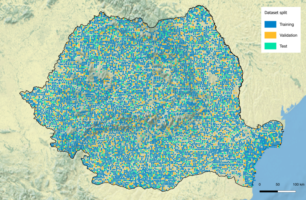
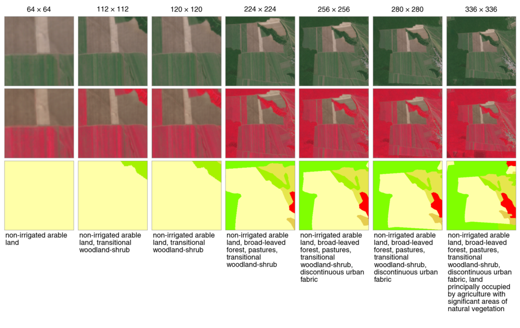
- 10,000 fixed locations × 8 scales = 80,000 labelled images. Every location is extracted at 64, 112, 120, 128, 224, 256, 280 and 336 pixels, at a constant 10 m GSD (40.96 to 1128.96 ha), all sharing identical patch centers.
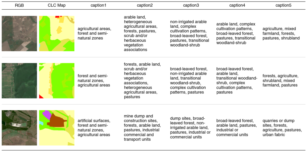
- Five annotation layers per patch. Each patch carries five deterministically generated multi-label sets: CLC Levels 1–3, the BigEarthNet nomenclature, and a custom Romania-adapted scheme. Every label is traceable to the rasterized CLC 2018 reference, with no manual or model-based annotation.
- Dual-use labels. Each label set is a comma-separated list, usable as text for vision–language models or split into a binary multi-label vector for classical classification, with no reformatting.
- Controlled acquisition. 12-band Level-2A BOA reflectance from 38 scenes, acquired within a nine-week window (9 August–14 October 2018) chosen for low cloud cover and stable phenology.
- Spatially separated partition. A single 70/15/15 split (7,000/1,500/1,500), stratified within each Sentinel-2 tile and propagated by patch identifier to every scale. No two footprints overlap at any scale. To limit spatial autocorrelation, evaluation patches that had a training neighbor within 5 km with an identical CLC Level-3 label set were swapped out (214 swaps); the few residual cases, all involving rare label combinations, are documented in the code repository.
- Quality-controlled imagery. All 10,000 patches were visually inspected in two independent review cycles, and footprint independence was re-verified on the released index.
- Geospatial-native formats. 16 archives (GeoTIFF and PNG) by format and scale, per-scale Parquet metadata, and a GeoPackage footprint index, ready for GDAL / GeoPandas workflows.
What the baselines show
Using ResNet-50 baselines, the benchmark isolates how spatial extent affects multi-label land-cover classification:
- The benefit of scale depends on semantic granularity. After accounting for the shifting chance floor, extra context brings little gain at CLC Level 1 but clear gains at Levels 2 and 3. Macro mAP at Level 3 rises from 0.42 at 64 px to 0.61 at 336 px, and the gains are strongest for mosaic classes whose definition is a landscape pattern rather than a single cover type.
- Gains saturate. Per-location improvement plateaus around 224–256 pixels.
- Transfer is asymmetric. Models trained on wide patches transfer to narrow ones far better than the reverse.
- Nomenclature matters as much as scale. On the same imagery, the choice of target vocabulary affects measured performance about as strongly as patch size does.
- The scale effect is robust. It survives distance-stratified and leave-scene-out controls for spatial leakage, holds under every labeling-rule threshold, and persists across ResNet-50 (from scratch and ImageNet-pretrained) and ViT-S/16 backbones.
The implication is methodological: patch size and nomenclature are design variables that should be reported explicitly, since results obtained under different settings are not directly comparable. SENSERO provides a shared, controlled basis for studying both, and closes a national-scale coverage gap for Romania, which is absent from the ten countries of BigEarthNet.
Availability and citation
The dataset, the full data-preparation pipeline, and the benchmark code are released openly under CC BY 4.0 and are described in the accompanying benchmark paper in Remote Sensing (MDPI).
- Paper: Costăchioiu, T.; Vasilescu, V.; Grivei, A.-C.; Griparis, A.; Faur, D. SENSERO: A Multi-Scale, Multi-Label Sentinel-2 Benchmark for Romania with Cross-Scale Land-Cover Classification Baselines. Remote Sens. 2026, 18, 3655. https://doi.org/10.3390/rs18213655
- Dataset (Zenodo): https://doi.org/10.5281/zenodo.18847389 (concept DOI; resolves to the latest version)
- Code and pipeline (GitHub): https://github.com/geosense-lab/SENSERO
- Correspondence: da**********@*pb.ro
We welcome use of SENSERO for benchmarking, methodological work on spatial scale and nomenclature, cross-country transfer, and regional Earth-observation research over Romania.
Authors publishing work based on SENSERO are invited to let us know, so that it can be listed among the related works on the dataset’s Zenodo record.